
How To Find Your Property On FEMA’s Flood Insurance Rate Maps

What are FEMA flood maps?
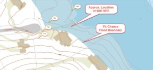
FEMA’s Flood Insurance Rate Maps (FIRMs) or just Flood Maps are provided after a flood risk assessment has been completed or updated for a community.  This study is known as a Flood Insurance Study.  The FIRM gives you the Base Flood Elevations (BFEs) and insurance risk zones in addition to floodplain boundaries.  The FIRM may also show a delineation of the regulatory floodway.

Once the “insurance risk zone”  (commonly referred to as the flood zone) is determined, actuarial rates, based on these risk zones, are then applied for newly constructed, substantially approved, and substantially damaged buildings.  FEMA uses these rates to determine the insurance rate you will pay for flood insurance

FEMA’s Digital Flood Maps

FEMA discontinued the production and distribution of paper flood maps in 2009 as part of its Digital Vision Initiative. This affected all the Flood Maps, boundary information, and study reports. However, clients can still view the products for free through their website or buy them in digital format.

To view these flood maps online, go to FEMA’s Map Service Center and key in your address (hi-lited area shown here) search for your home.  This will prompt you to then select the map that covers your area.  The Flood Maps are somewhat cumbersome to use online. It is best to go through the tutorial on the bottom right of the address search page for an easier and more effective use of the GIS map.

author avatar
Surveyor

More Posts

A homeowner and land surveyor checking the property line before building a residential fence
boundary surveying
Surveyor

Can You Build a Fence on the Property Line?

Yes, you can build a fence on the property line. But “can” and “should” are not the same thing. Before you set a single post, you need to know where that line actually sits. Guess wrong, and you could end up tearing down a fence you just paid for. This

Read More »
Homebuyers reviewing a property survey before purchasing a home
land surveying
Surveyor

Do You Really Need a New Survey When Buying Property?

Many buyers assume that if a survey already exists for a property, it is good enough to use at closing. Sometimes that is true. But in Iowa, whether an older survey is still reliable depends on several things. What has changed on the property, what the lender or title company

Read More »
Land surveyor using surveying equipment to measure a property near a construction site
land surveying
Surveyor

Types of Land Surveys Explained: A Complete Guide for Property Owners

Land surveys are important legal documents. If you own property or plan to buy some, you should understand the different types of land surveys. Each type serves a different purpose. Some surveys focus on property boundaries. Others map the ground elevation. Some surveys verify that buildings are in the right

Read More »

Welcome to ALTA Survey Iowa

Your Final Stop for Your ALTA Survey Needs!                              Contact us today for a free quote! This site is intended to provide you with information on ALTA Surveying in Iowa. If you’re looking for a Iowa Land

Read More »